Find Nearest Gas Station on Google Maps
Many people don’t know about this feature on Google Maps. Well, it’s very easy to know the nearest gas station near you on Google Maps. This process is almost identical on Android and iOS, and here is how you can find the nearest gas station:
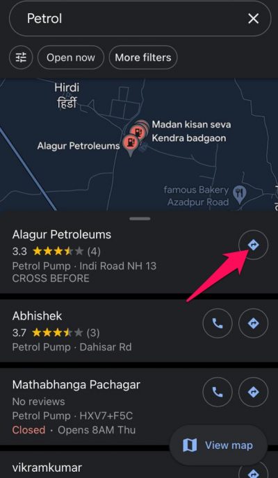
Open Google Maps on your Android or iOS device, and click on the Petrol or Gas option at the top.
After you click on the options, Google Maps will show all petrol or gas stations near you and if the gas station is open or closed.Click on the directions option on the gas station you want to visit, and Google Maps will show the shortest route to the petrol station.
Wrapping Up
This was how you can find the nearest gas station on Google Maps. Using Google Maps, you can know anything, including the address, operating hours, user ratings, etc. We hope the steps mentioned above were able to help you. Still, if you have any issues, feel free to drop a comment below.
Does Google Maps include gas stops?
Yes, you can add stops on Google Maps to get more accurate destination time.
How do I get fuel prices on Google Maps?
This feature was recently added to the app. You need to open the app and click on the gas button under the search bar. Then all gas stations near you will be shown with the gas price per gallon. RELATED GUIDES:
How To Run Google Play Store On Windows 11How To Enable Google Docs Dark ModeFix Your Device Isn’t Compatible with this Version on Google Play StoreHow To Fix Google Play Services Keeps Stopping
Δ